It
was about 4 am when the camp steward woke me with the customary canned orange
juice. And then to the mess tent where the seismic party’s surveyor, Ron
Townsend was swaddled in a woolen blanket. The night air in northern Ras al
Khaimah can be surprisingly chilly. Back in 1969, Radio Luxemburg could still
be heard from 4000 miles away and the disc jockeys made a bizarre accompaniment
to our breakfast. Ron mumbled that he
hoped the morning would not bring a repeat of his experience of the day before
when the Shihuh tribesmen from the mountains had taken pot-shots at him as he traversed
their territory. I had no clue who these mysterious Shihuh were but years later
I found out that my father had experienced similar encounters in the early
1950s when on geological field parties in Oman with the Iraq Petroleum Company.
Who were these mysterious Shihuh and why are they so belligerent?

Map of Oman and the Musandam peninsula (File image)
The
Shihuh are a “tribe” who inhabit the Hagar mountain range which dominates the
Musandam landscape of northernmost Oman and which extends west into Ras al
Khaimah. To the north, the Hagar plunges
dramatically into the sea where the coast is characterized by long “kawrs” or
inlets. Geologically, the peninsula consists of a vast outcrop of Mesozoic-age
carbonate rocks situated on the Arabian tectonic plate. As this plate continues
on its collision course with the Eurasian plate to the northeast, the northern
tip of Musandam is subsiding at the extraordinarily fast rate of 6 - 8 mm per
year. It is this subsidence, combined with post-glacial sea-level rises, that produces
the drowned fjord-like coastline.

A classic Musandam view of the kawr coastline (file photograph)
The
earliest archaeological artifacts found in the area have been Palaeolithic
tools from Omani caves. Tombs which have included both human remains and
pottery dating back to the Bronze Age have been found in both Oman and the
UAE. The Sumerians from Mesopotamia, the
ancient Greeks, Turks and Persians have all passed though the region until the Portuguese
established themselves in Oman, including Musandam, by the mid-1500s. Early Portuguese maps of the area do show a
settlement in the area and the Persian fort in Khasab (which was, and is, Musandam’s
largest town) was rebuilt by the Portuguese. They were eventually driven out by
Imam Sultan Bin Saifthe in 1650. By now,
the British were expanding their sphere of influence in Arabia and the special relationship
between Oman and the British dates from 1798 when the first treaty of “friendship and protection” was signed.
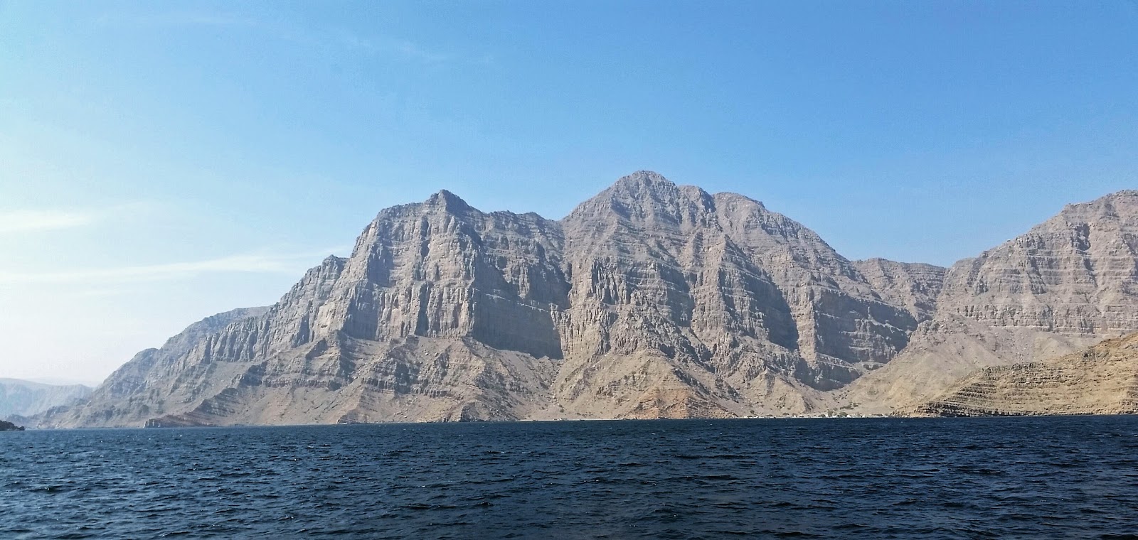
The impenetrable Hagar mountains from the sea (William Hudson, 2016)
Oman
lay on the great trading routes between India and Africa. The magnificent wooden dhows with their large
triangular sails crossed from one continent to the other and it is no accident
that Mombasa, Zanzibar, Mogadishu, Aden and Muscat all share remarkable similarities. Some of these ships undoubtedly stopped in
Khasab en route.

A dhow in the waters of the Trucial Coast (IPC expedition photo from the 1950s)

A dhow under construction in Ras al Kahimah (William Hudson, 1969)
By the 19th century, the Omani
empire extended from Zanzibar to Persia and was very actively involved in the
East African slave trade. Like any trading people, Omanis are inevitably a
genetic admixture and African blood is undoubtedly part of the mix.

Extent of the Omani Empire in the mid-19th century (GeoCurrents file image)
The
isolation of the Hagar mountains perhaps results in a less-complicated genetic history.
Nearly all of Musandam’s indigenous people are Shihuh, generally considered to
be early migrants from the highlands of Yemen, probably intermingled with
Persian blood. Musandam is an isolated, harsh environment where temperatures
can reach over 120 Fahrenheit in the summer. Most of the peninsula was
historically only accessible from the sea and the Shihuh are historically very hostile
to outsiders though less so since first the graded tracks into the mountains were
built in 1981.
The
northernmost town is Kumzar where densely-packed houses sit wedged together at
the base of a steep gorge. Here, the local Shihuh population speak a unique
amalgam of Arabic and Farsi; Iran is only a short 35 miles across the Straits
of Hormuz. Most of the vocabulary and
grammar is Persian, although a large number of Arabic words exist in the
everyday speech. Today, members of the younger generation tend to learn Arabic
instead of the language of their parents. The days of their unique dialect are probably
numbered.
The
Shihuh survive on fishing and subsistence agriculture, primarily raising goats
and growing barley and dates. They are semi-nomadic: living in barasti huts on
the coast and in stone dwellings (bayt al qufl)
in the mountains, migrating between the two according to the seasons.

A mountain bayt al qufl (William Hudson, 2016)
Their
farming depends on run-off irrigation from unreliable rains which is channeled into
irrigation systems, some of which date back to the Iron Age.

Cultivation in a high plain in the Hagar mountains (William Hudson, 2016)
The bayt al qufl usually contain ceramic
storage jars used for storing oil, grain and water. This unglazed, coarse
earthenware is known as Julfar Ware and has been dated back to the 14th
century. Several kiln sites have been discovered, the best known of which is
from the Shimal area of northern Ras al-Khaimah. Julfar Ware was still being made, with
minimal changes, until the 1970s.

Julfar Ware in an bayt al qufl (William Hudson, 2016)
The Shihuh also exhibit a culture of rock art
(etched petroglyphs). Some date back to the 4th millennium BC while
others are very recent. Animals that have been depicted include ibex, leopards,
ostriches, horses and camels.

Shihuh petroglyphs high in the mountains of Musandam (William Hudson, 2016)
In
much of the Gulf Region, the ornate, sheathed knife known as a khanja is ubiquitous and very ornate
ones often indicate the high social status of the owner.

An Omani kahnjar
("Swords
and Antique Weapons" file photograph)

A Gulf-state Sheik's son, wearing a traditional khanjar
(IPC expedition photo from the 1950s)
The Shihuh, however,
carry a jerz, the long-handled axe
that is unique to Musandam. The head is small (2-3 inches) and can either be
very simple or might be decorated with intricate inlay. Prototypes date back thousands of years but predictably,
many of those available today are imported from India.

A Shihuh jerz (thesaleroom.com file photograph)
Fiercely
protecting their isolation and independence, a Shihuh sheikh wrote to the British
Representative in 1930: “We will declare
Jihad and kill whosoever arrives in our quarter and will allow none of them to
return”. Both Ron Townsend and my
father were, perhaps, lucky to have made it out unscathed.

The enigmatic Musandam peninsular from space
(NASA file photograph)
BIBLIOGRAPHY
Costa, Paolo M. Musandam: Architecture and Material Culture
of a Little Known Region of Oman. Immel Publishing, London 1991.
Dostal, Walter. The Shihuh of Northern Oman. In “The
Geographical Journal”, Vol 138, 1972.
Falcon, N. L.. The Musandam Expedition 1971-1972. In “The Geographical Journal”, Vol 139, 1973.
Feulner, Gary. Geological
Overview in The Emirates, a Natural
History. Trident Press, 2006
Fossati, Angelo
Eugenio. Rock
Art in Jebel Akhdar, Oman. In “TRACCE Online Rock Art Bulletin”, Milan,
2015.
Morton, Michael
Qentin.
In the Heart of the Desert. Green
Mountain Press, Aylesford 2006.
Morton, Michael
Qentin.
Keepers of the Golden Shore. A History of
the United Arab Emirates. Reaktion Books, London 2016.
Rothaus, Richard. The Musandam Peninsula Oman Expedition.
In “The Minnesota Archaeologist”, Vol 70, 2011
Western, Rob. The Southern Ruus al Jibal – an Introduction
to its People and Natural History. Bulletin 25, Emirates Natural History
Group, 1985.
2 comments:
That's fascinating, William. Thanks for sharing that. I hope that all is well this holiday season.
Great post — very informative! In construction and industrial projects, site area tents play a vital role in providing comfort, shade, and protection for workers. For durable and weather-resistant options across the UAE, check out Star Tents, a trusted provider of high-quality site area tents and shelters.
Post a Comment